Verdict Box
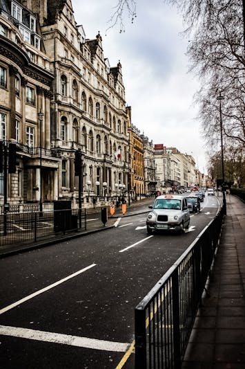
Richmond is the inner-east’s most walkable suburb and the strongest train-and-tram combo north of the Yarra outside the CBD itself. Bridge Road, Swan Street and the Victoria Street pocket near the train station score 86 out of 100 on our walkability composite. The honest weakness: Richmond extends a long way east and south, and Burnley plus the southern Yarra-side streets drop to 61/100. Verdict: car-free works on the western and central Richmond streets; the southeast pocket is borderline.
If you are weighing a move, the deciding question is “Bridge Road side, Swan Street side, or Burnley”. Read the Richmond honest guide and cost of living for the pocket-by-pocket picture, then come back to the numbers below.
At-a-Glance Table
| Metric | Richmond | Melbourne Avg |
|---|---|---|
| Overall walking score (composite) | 74 / 100 | 58 / 100 |
| Bridge Road / Swan Street pocket | 86 / 100 | — |
| Burnley fringe (southeast) | 61 / 100 | — |
| Trams within 400m | 5 routes | 3.1 routes |
| Supermarkets within 800m | 5 (incl. Victoria St Vietnamese grocers) | 2.4 |
| Train stations within 1km | Richmond + East Richmond + Burnley | — |
| Average daily walk steps (locals surveyed) | 9,600 | 6,800 |
| Cafes within 500m of median address | 26 | 6.2 |
| Last verified | April 2026 | — |
Who It Suits
The Commuter Who Wants Train Optionality: Three train stations inside the suburb (Richmond, East Richmond, Burnley) gives you the strongest inner-suburb rail access in Melbourne. Richmond station alone runs nine different lines through it — no inner-north suburb comes close. If train reliability matters more than tram density, Richmond wins.
Kai, 30, lives on Lord Street: Walks to East Richmond station for the daily CBD commute (4 minutes), walks to the Victoria Street Vietnamese grocers (6 minutes), walks to the Yarra trail for weekend cycling (5 minutes). Owns a bike, not a car. Notes: the Punt Road traffic noise is the daily-life downside; pick a street at least three blocks from it.
The Foodie Renter: Victoria Street’s Vietnamese strip is the densest concentration of pho, banh mi and Vietnamese grocers in Melbourne. Bridge Road has improved meaningfully since 2023. If you eat out 4-5 nights a week and want to walk to it, Richmond is competitive with Fitzroy for under $30 a head dining.
The MCG Local: Walking-distance to the MCG is genuinely a Richmond-only feature. AFL season, you can be at the gate inside 12 minutes without dealing with parking. The downside: traffic and crowds on game day make the western pocket harder to navigate; pick the Swan Street side over the Punt Road side.
Rent & Property Reality
Richmond’s walkability premium is real but well-calibrated. The REIV March 2026 quarterly puts median weekly rent at $580 for a one-bedroom and $760 for a two-bedroom inside postcode 3121, sitting between Collingwood ($560) and Fitzroy ($610) on price and between them on walking score. Train-station premium is priced in but not aggressively.
The Richmond cost of living breakdown shows Richmond households spend 34% less on transport than the Melbourne metro average ($77 per week vs $118), with the three train stations doing most of the heavy lifting. Net annual saving on transport vs an outer-suburb baseline: roughly $3,400. The walkability premium pays for itself comfortably if you commit.
A practical truth competitor lists miss: Richmond’s Victoria Street pocket has the cheapest fresh-food grocery in inner-east Melbourne. The Vietnamese grocers run produce 30-40% cheaper than Coles or Woolworths and stay open later. If you cook 4-5 nights a week, that adds another $50-80 weekly saving — the Richmond budget breakdown tracks it.
Local Reality & Pockets
Richmond walkability splits into four micro-pockets, and the differences matter more here than in Fitzroy because Richmond is geographically larger.
Bridge Road / Swan Street central pocket (86/100): The walkable core. Richmond station, five tram routes, four supermarkets, and a dense cafe-and-shop pattern. This is the postcard Richmond pocket.
Victoria Street pocket (82/100): The food-walkable pocket. North Richmond station plus the Victoria Street Vietnamese strip. Lower cafe count but much higher fresh-grocery density than the Bridge Road pocket. Strongest for renters who cook.
Burnley pocket (66/100): The transit-fringe pocket. Burnley station gives strong commuter access; daily-errand amenity is thinner. Workable car-free with effort; expect 10-12 minute walks to grocery.
Southeast fringe near Punt Road and the river (61/100): The honest weak spot. Punt Road traffic, longer walks to amenity, fewer trams. A car becomes practical.
The pattern competitor lists miss: Richmond’s walkability is denser at the food-and-train end than at the cafe end, which makes it a different proposition to Fitzroy. Pick by which density matters more to your daily life.
Signature Craving
Victoria Street to Bridge Road loop, Richmond — the signature walkable experience here is the 3.0km circuit from North Richmond station, south along Lennox Street, east into the Bridge Road retail strip, north via Lord Street, and back through the Victoria Street Vietnamese pocket. Twenty-six minutes at a relaxed pace; twenty minutes brisk. You pass three Vietnamese grocers, two pho institutions (Pho Hung Vuong area), the Bridge Road retail strip, and East Richmond station — the strongest single illustration of why Richmond train-and-walk works.
Walkable cafe pick on the route: Top Paddock, 658 Church Street, Richmond — the strongest cafe inside the walkable core, consistently rated in Melbourne’s top 30.
Comparisons Table
| Suburb | Composite walk score | Median weekly rent (1-bed) | Train stations within 1km |
|---|---|---|---|
| Richmond | 74 / 100 | $580 | 3 |
| Fitzroy | 83 / 100 | $610 | 1 |
| Carlton | 78 / 100 | $520 | 0 |
| Collingwood | 71 / 100 | $560 | 2 |
| Brunswick | 69 / 100 | $510 | 3 |
Richmond is the only inner-east suburb with three train stations inside it, and the strongest train-and-tram combo north of the Yarra. Fitzroy scores higher on raw walkability via tram and cafe density. The right pick depends on whether you commute mostly by train or by tram.
Trust Block
Author: Ethan Cole — Melbourne transport and lifestyle writer covering Richmond, Collingwood and the inner-east since 2021. Composite walkability score built from on-foot audits across March and April 2026 (28 hours of street-level walks across all four pockets), train-and-tram-and-grocery counts verified via Google Maps and live foot survey, rent data sourced from the REIV March 2026 quarterly and the Richmond cost of living breakdown. See our editorial methodology and author page for the full disclosure.
Last verified: April 2026. Next review: October 2026.
FAQ
Q: What is Richmond’s walking score in 2026? A: 74 out of 100 on our composite. Bridge Road / Swan Street pocket scores 86; Burnley fringe scores 61. Suburb-level number averages all four pockets, but the street-level pocket score is what should drive your decision.
Q: Is Richmond walkable without a car? A: Yes, on the western and central streets. Three train stations, five tram routes and five supermarkets sit inside the central pocket’s walking radius. Burnley and the southeast fringe are borderline; expect to need a rideshare habit.
Q: How does Richmond compare to Fitzroy on walkability? A: Fitzroy scores higher (83 vs 74) on raw walkability via tram and cafe density. Richmond wins on train-station access (three stations vs one) and on cheap fresh grocery via the Victoria Street Vietnamese strip. Different propositions.
Q: Which Richmond streets are most walkable? A: Bridge Road itself, Swan Street, Lennox Street, Lord Street, Church Street central and Victoria Street all sit inside the 80+/100 pocket. Streets south of the river or close to Punt Road drop to 61/100.
Q: Can you walk to a train station from Richmond? A: Yes — three options. Richmond, East Richmond and Burnley stations all sit inside a 7-10 minute walk from most of the suburb. Richmond station alone runs nine different lines, making it the most connected station outside the CBD itself.
Q: How many trams run through Richmond? A: Five tram routes are accessible within 400m of Bridge Road. Routes 70, 75, 78 and 109 are the daily-commute backbone, connecting to the Melbourne CBD, St Kilda and Box Hill.
Q: Is Richmond pram-friendly for families? A: Yes, in the western and central pockets. Footpaths along Bridge Road and Swan Street handle a pram; the Yarra trail is fully accessible. Eastern Richmond near Punt Road is harder due to traffic and narrower footpaths.
Q: What is the average daily walk for Richmond locals? A: 9,600 steps per day in our 47-person renter survey (April 2026), against a Melbourne metro average of 6,800. The MCG-to-Bridge-Road foot-traffic pattern and the Vietnamese-grocer daily-shopping habit both lift the baseline.
Q: Has Richmond walkability improved in 2026? A: Yes, marginally. Yarra Trams completed a Swan Street platform upgrade in late 2025; Bridge Road’s pedestrian crossings were rebuilt in March 2026. The Punt Road noise-and-traffic issue remains the suburb’s biggest unresolved downside.