Verdict Box
What most guides miss: the paths are flawless—but firmly urban.
- Best for: Young families and commuter-cyclists who value modern, safe, and pram-friendly paths over rugged nature.
- Skip if: You’re seeking challenging hikes, elevation changes, or the feeling of being truly ‘away from it all’.
- Rent pressure: High. The suburb’s master-planned appeal and direct train line keep demand strong and vacancy rates low.
- Commute reality: A-grade via the train station in the suburb’s heart. C-grade via the Princes Freeway (M1) during peak hour, which is notoriously congested.
- Food outlook: Functional, not a destination. Dominated by chains and family-friendly eateries within the central shopping precinct.
- Family fit: A+. The entire suburb was engineered for families, with interconnected parks, modern playgrounds, and wide, safe footpaths.
- Overall score: B+
At-a-Glance Table
| Metric | Williams Landing | Victoria Avg. |
|---|---|---|
| Median Rent (3br house) | ~$550/week | ~$480/week |
| Violent Crime Rate | Significantly Lower | State Average |
| Public Transit Access | Excellent (Zone 2 Station) | Varies |
| Walk Score® | 68/100 (Somewhat Walkable) | Varies |
| Average Dwell Time | 5-7 Years | 9 Years |
Who It Suits
Quick read: who actually thrives here?
- The Pram-Pushing Parent: Flat, wide, interconnected footpaths and playground-dotted parks are non-negotiable.
- The Commuter-Cyclist: Needs direct, seamless access to the Federation Trail for a car-free journey towards the city or Werribee.
- The Fitness-Focused Resident: Wants a safe, well-lit 5km running loop around the wetlands for morning or evening exercise.
- The Downsizer: Seeks a low-maintenance townhouse or apartment with level, accessible paths for daily, gentle strolls to the shops and train station.
Rent & Property Reality
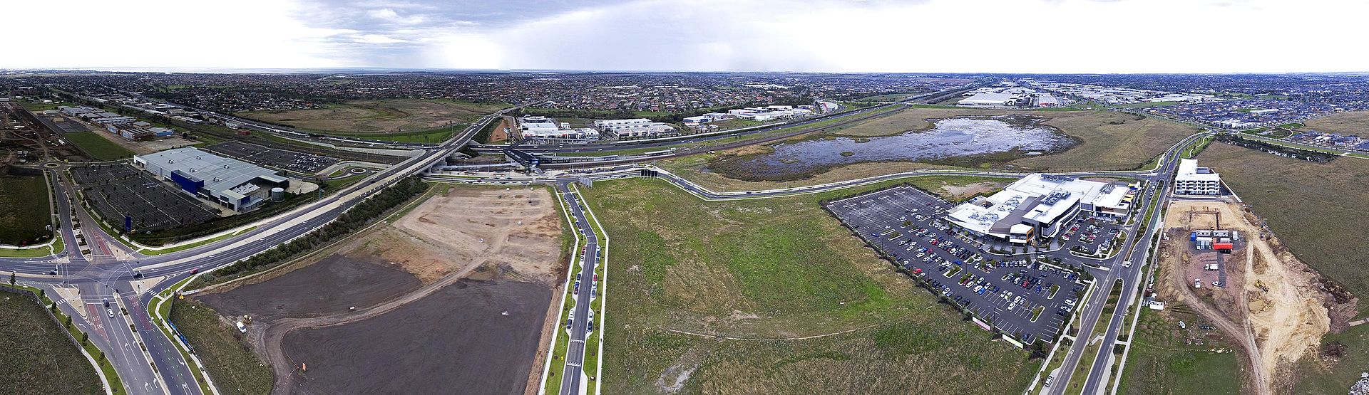
Williams Landing is a master-planned suburb where your property choice sets your walkability. Palmers Road splits the map. The station and shops are the gravity well. Living close costs more. Here’s the trade-off most renters miss: pay for proximity or pay in time.
Apartments near Overton Road unlock true car-light living. Expect to pay around $480-$520 per week for a two-bedroom apartment in the multi-storey cluster by the station. Groceries, gym, medical, and platform are inside a 500m radius. Daily errands become short walks on flat, lit paths. What you give up in backyard you regain in daily steps.
Further out, detached homes push rents to roughly $550–$580 for a 3-bed. You gain private space and a real backyard, but quick trips often mean a short drive. The footpath web and pocket parks still make local loops easy. Green links are calmer and feel self-contained. The honest reality: space grows, convenience shrinks.
Local Reality & Pockets
Forget romantic notions of rugged bushland. Walking in Williams Landing is about smart, modern design. Paths are engineered, wetlands are curated, and lighting is deliberate. Safety and accessibility rule every decision. What most guides miss: that’s the feature, not a bug.
Walk 1: The Williams Landing Wetlands Circuit (5km Loop) This is the suburb’s signature route. Start near the shopping centre on Overton Road and head south onto the sealed path. The circuit is almost exactly 5km—perfect for timed laps. Flat grade makes it ideal for prams and beginners. Here’s the kicker: it stays usable in most weather thanks to drainage and lighting.
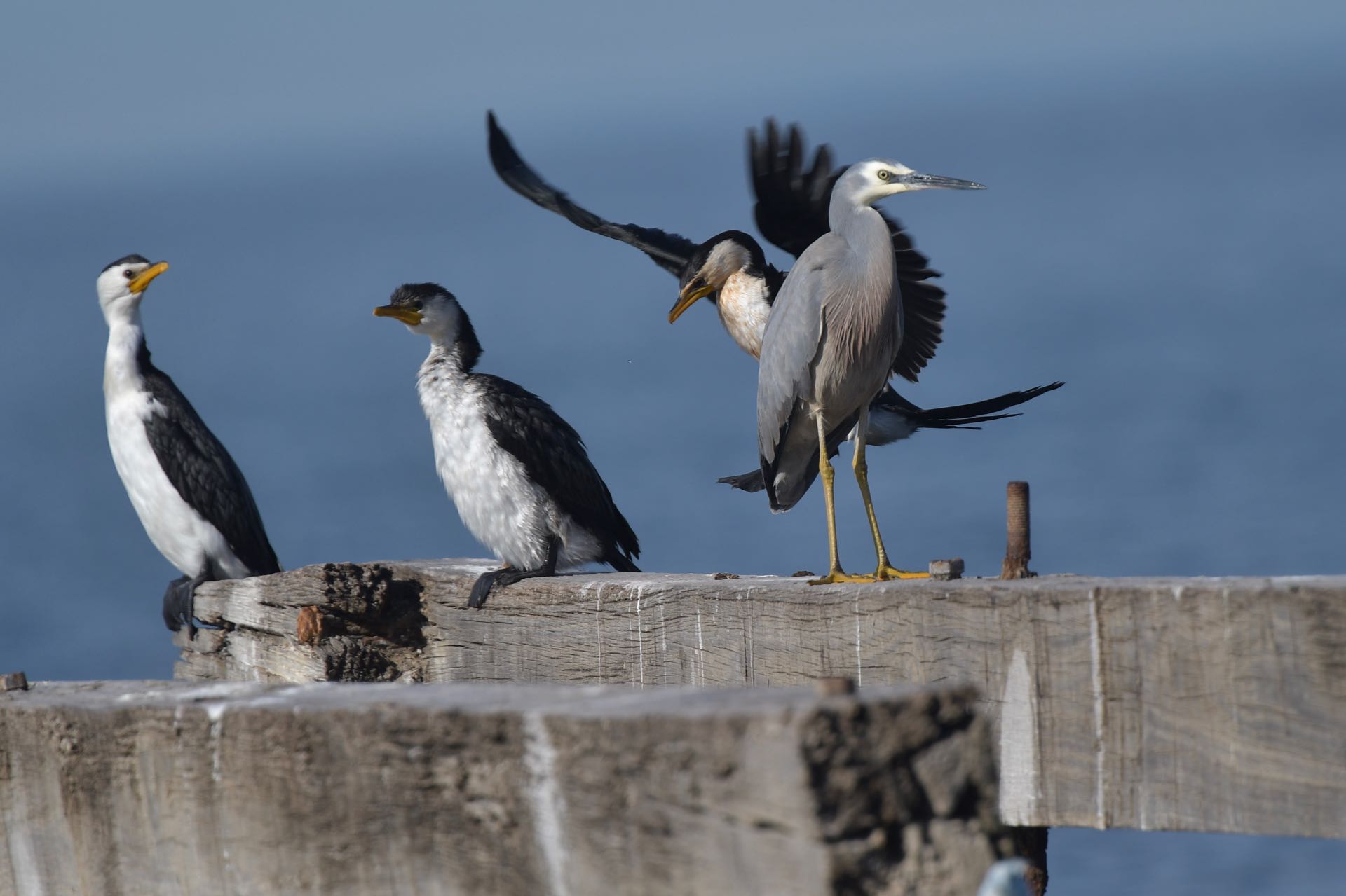
Boardwalks carry you over the water with viewing platforms for bird-spotting. Expect coots, dusky moorhens, swamphens—plus the odd pelican. Outdoor gym stations break up the monotony for cross-training. Night lighting extends safe hours for runners. Reality check: summer shade is limited and a freeway hum is constant.
Walk 2: Federation Trail Connection (The Commuter’s Path) Access is seamless from the station. Head 400m north along Palmers Road to the signposted entry. East links towards Laverton and the city; west heads to Hoppers Crossing and Werribee. Surfaces are wide, flat, and fast. What most guides gloss over: it’s functional, not scenic—and freeway noise is part of the deal.
This is a transport corridor first. It excels for cycle commutes and long, uninterrupted runs. Crossings and stops are minimal, so pacing is easy. Wayfinding is clear for new users. Google won’t tell you how practical it feels until you ride it.
Walk 3: Residential Green Links (Build-Your-Own Loops) The quieter experience lives in the residential spines. Start at Ashcroft Park and weave south via Elmhurst Drive and Wingate Avenue. Link up with Williams Landing Boulevard Park or the wetlands. Manicured verges and modern homes line the way. Here’s the quiet win: safe kid routes to parks without tangling with main roads.
Signature Craving
After a 5km loop, you want reliable fuel fast. Most options cluster inside and around the shopping centre. Think Guzman y Gomez for a burrito, Domino’s for a quick slice, plus local takeaways. Easy in, easy out, and family-forward seating. The honest reality: this strip is built for speed, not destination dining.
The local anchor is The Landing Hotel. It’s the go-to for weeknight meals and weekend catch-ups. Expect a broad bistro menu—parmas, steaks, pizzas, salads—and a modern fit-out. Service is streamlined for families and groups. What you get: consistent pub classics a short walk from the loop.
Comparisons Table
| Suburb | Rent (1BR Apt) | Green Space Access | Parking | Best for |
|---|---|---|---|---|
| Williams Landing | ~$420/week | Engineered wetlands, linear parks | Difficult near station, easy elsewhere | Train commuters & new-build lovers |
| Point Cook | ~$390/week | Abundant but disconnected parks, coastal path | Generally easy, but congested town centre | Larger homes & established family amenities |
| Hoppers Crossing | ~$350/week | Traditional parks, Werribee River access | Abundant street parking | Budget-conscious buyers seeking larger blocks |
| Laverton | ~$340/week | Federation Trail, basic local parks | Easy | Proximity to industrial zones & city-bound transit |
Trust Block
Author: Priya Sharma
Priya is MELBZ’s family-and-community correspondent, specialising in the urban planning and lived reality of Melbourne’s growth corridors. She has analysed Wyndham City Council’s structure plans for the area since 2015.
Data Sources: Australian Bureau of Statistics (ABS), Domain.com.au Suburb Profiles, Wyndham City Council, VicRoads, Public Transport Victoria (PTV), Crime Statistics Agency Victoria. This article is based on data available up to Q2 2024.
Disclaimer: This article is for informational purposes only and does not constitute financial or real estate advice. Always conduct your own research.
FAQ
Q: How long is the Williams Landing wetlands loop (exact km)? Almost exactly 5km on a flat, sealed path. Runners use it for timed laps and prams roll easily the whole way.
Q: Where’s the best start and parking for the wetlands walk? Start at Williams Landing Shopping Centre on Overton Rd. Timed centre parking and nearby street parking give direct access to the loop.
Q: Is the wetlands loop lit and safe for night runs? Yes, key sections are well-lit and feel active into the evening. As always, run with awareness and stick to the main loop.
Q: Are dogs allowed on the Williams Landing wetlands paths? Yes, on-leash. The paths are wide but shared with cyclists—keep left and bring waste bags.
Q: Can I access the Federation Trail directly from the station? Yes. Walk 400m north up Palmers Rd to the signposted entry. From there you can head east towards Laverton/City or west to Hoppers Crossing/Werribee.
Q: How noisy is the Federation Trail near Williams Landing? Moderate to high traffic noise—sections run by the freeway. It’s fast and functional rather than scenic.
Q: Are there playgrounds or exercise stations on the loop? Yes. The wetlands circuit includes outdoor gym equipment, and nearby parks like Ashcroft Park and Williams Landing Boulevard Park have play areas.
Q: Any hills or elevation on these walks? No. Williams Landing is almost completely flat, designed for accessibility—not for hill training.
Q: What wildlife can I see from the boardwalks? Expect dusky moorhens, Eurasian coots, purple swamphens, ducks, and occasional pelicans—an urban wetlands experience.
Q: Are the paths pram and wheelchair friendly? Extremely. Wide, sealed, and with curb ramps throughout. One of the more accessible walking areas in Melbourne’s west.
Q: Are there public toilets on or near the loop? Use facilities at the shopping centre and the train station at the start of the loop; there are no toilets mid-trail.
Q: How far can I go on the Federation Trail from here? It runs for tens of kilometres. East connects towards Laverton and city-bound links; west continues past Hoppers Crossing to Werribee.
“\n{\n "@context": "https://schema.org",\n "@graph": [\n {\n "@type": "Organization",\n "@id": "https://melbz.com.au/#organization",\n "name": "MELBZ",\n "url": "https://melbz.com.au/",\n "logo": {\n "@type": "ImageObject",\n "url": "https://melbz.com.au/images/melbz-logo.png",\n "width": 600,\n "height": 60\n },\n "sameAs": [\n "https://x.com/melbzau",\n "https://instagram.com/melbz101"\n ]\n },\n {\n "@type": "WebPage",\n "@id": "https://melbz.com.au/williams-landing/best-walks/",\n "url": "https://melbz.com.au/williams-landing/best-walks/",\n "name": "Williams Landing Walks 2026: The 3 Routes Locals Use Daily",\n "description": "Your 2026 guide to Williams Landing walks: the 5km wetlands loop, fast Federation Trail access, and quiet green links—plus real tips on shade, safety and parking.",\n "inLanguage": "en-AU",\n "isPartOf": {\n "@id": "https://melbz.com.au/#website"\n },\n "primaryImageOfPage": {\n "@type": "ImageObject",\n "url": "https://images.unsplash.com/photo-1642939646286-b20a6796bce1?crop=entropy\u0026cs=tinysrgb\u0026fit=max\u0026fm=jpg\u0026ixid=M3w5MDM1ODN8MHwxfHNlYXJjaHwxfHxzdWJ1cmJhbiUyMHdldGxhbmRzJTIwcGF0aCUyMFdpbGxpYW1zJTIwTGFuZGluZyUyMG1lbGJvdXJuZXxlbnwxfDB8fHwxNzc5NDU5Mjc0fDA\u0026ixlib=rb-4.1.0\u0026q=80\u0026w=1080"\n },\n "speakable": {\n "@type": "SpeakableSpecification",\n "cssSelector": [\n ".verdict-box",\n ".at-a-glance",\n ".faq"\n ]\n }\n },\n {\n "@type": "Article",\n "@id": "https://melbz.com.au/williams-landing/best-walks/#article",\n "headline": "Williams Landing Walks 2026: The 3 Routes Locals Use Daily",\n "description": "Your 2026 guide to Williams Landing walks: the 5km wetlands loop, fast Federation Trail access, and quiet green links—plus real tips on shade, safety and parking.",\n "image": [\n "https://images.unsplash.com/photo-1642939646286-b20a6796bce1?crop=entropy\u0026cs=tinysrgb\u0026fit=max\u0026fm=jpg\u0026ixid=M3w5MDM1ODN8MHwxfHNlYXJjaHwxfHxzdWJ1cmJhbiUyMHdldGxhbmRzJTIwcGF0aCUyMFdpbGxpYW1zJTIwTGFuZGluZyUyMG1lbGJvdXJuZXxlbnwxfDB8fHwxNzc5NDU5Mjc0fDA\u0026ixlib=rb-4.1.0\u0026q=80\u0026w=1080"\n ],\n "datePublished": "2026-05-22",\n "dateModified": "2026-05-22",\n "author": {\n "@type": "Person",\n "name": "Priya Sharma",\n "url": "https://melbz.com.au/authors/priya-sharma/",\n "description": "Family-and-community correspondent; reads council planning notices for fun."\n },\n "publisher": {\n "@id": "https://melbz.com.au/#organization"\n },\n "mainEntityOfPage": {\n "@id": "https://melbz.com.au/williams-landing/best-walks/"\n },\n "articleSection": "things-to-do",\n "keywords": [\n "williams landing",\n "best walks",\n "melbourne",\n "things-to-do",\n "2026"\n ],\n "inLanguage": "en-AU"\n },\n {\n "@type": "BreadcrumbList",\n "@id": "https://melbz.com.au/williams-landing/best-walks/#breadcrumb",\n "itemListElement": [\n {\n "@type": "ListItem",\n "position": 1,\n "name": "Home",\n "item": "https://melbz.com.au/"\n },\n {\n "@type": "ListItem",\n "position": 2,\n "name": "Williams Landing",\n "item": "https://melbz.com.au/williams-landing/"\n },\n {\n "@type": "ListItem",\n "position": 3,\n "name": "Best Walks",\n "item": "https://melbz.com.au/williams-landing/best-walks//"\n }\n ]\n },\n {\n "@type": "FAQPage",\n "@id": "https://melbz.com.au/williams-landing/best-walks/#faq",\n "mainEntity": [\n {\n "@type": "Question",\n "name": "How long is the Williams Landing wetlands loop (exact km)?",\n "acceptedAnswer": {\n "@type": "Answer",\n "text": "Almost exactly 5km on a flat, sealed path. Runners use it for timed laps and prams roll easily the whole way."\n }\n },\n {\n "@type": "Question",\n "name": "Where’s the best start and parking for the wetlands walk?",\n "acceptedAnswer": {\n "@type": "Answer",\n "text": "Start at Williams Landing Shopping Centre on Overton Rd. Timed centre parking and nearby street parking give direct access to the loop."\n }\n },\n {\n "@type": "Question",\n "name": "Is the wetlands loop lit and safe for night runs?",\n "acceptedAnswer": {\n "@type": "Answer",\n "text": "Yes, key sections are well-lit and feel active into the evening. As always, run with awareness and stick to the main loop."\n }\n },\n {\n "@type": "Question",\n "name": "Are dogs allowed on the Williams Landing wetlands paths?",\n "acceptedAnswer": {\n "@type": "Answer",\n "text": "Yes, on-leash. The paths are wide but shared with cyclists—keep left and bring waste bags."\n }\n },\n {\n "@type": "Question",\n "name": "Can I access the Federation Trail directly from the station?",\n "acceptedAnswer": {\n "@type": "Answer",\n "text": "Yes. Walk 400m north up Palmers Rd to the signposted entry. From there you can head east towards Laverton/City or west to Hoppers Crossing/Werribee."\n }\n },\n {\n "@type": "Question",\n "name": "How noisy is the Federation Trail near Williams Landing?",\n "acceptedAnswer": {\n "@type": "Answer",\n "text": "Moderate to high traffic noise—sections run by the freeway. It’s fast and functional rather than scenic."\n }\n },\n {\n "@type": "Question",\n "name": "Are there playgrounds or exercise stations on the loop?",\n "acceptedAnswer": {\n "@type": "Answer",\n "text": "Yes. The wetlands circuit includes outdoor gym equipment, and nearby parks like Ashcroft Park and Williams Landing Boulevard Park have play areas."\n }\n },\n {\n "@type": "Question",\n "name": "Any hills or elevation on these walks?",\n "acceptedAnswer": {\n "@type": "Answer",\n "text": "No. Williams Landing is almost completely flat, designed for accessibility—not for hill training."\n }\n },\n {\n "@type": "Question",\n "name": "What wildlife can I see from the boardwalks?",\n "acceptedAnswer": {\n "@type": "Answer",\n "text": "Expect dusky moorhens, Eurasian coots, purple swamphens, ducks, and occasional pelicans—an urban wetlands experience."\n }\n },\n {\n "@type": "Question",\n "name": "Are the paths pram and wheelchair friendly?",\n "acceptedAnswer": {\n "@type": "Answer",\n "text": "Extremely. Wide, sealed, and with curb ramps throughout. One of the more accessible walking areas in Melbourne’s west."\n }\n },\n {\n "@type": "Question",\n "name": "Are there public toilets on or near the loop?",\n "acceptedAnswer": {\n "@type": "Answer",\n "text": "Use facilities at the shopping centre and the train station at the start of the loop; there are no toilets mid-trail."\n }\n },\n {\n "@type": "Question",\n "name": "How far can I go on the Federation Trail from here?",\n "acceptedAnswer": {\n "@type": "Answer",\n "text": "It runs for tens of kilometres. East connects towards Laverton and city-bound links; west continues past Hoppers Crossing to Werribee."\n }\n }\n ]\n },\n {\n "@type": "Place",\n "@id": "https://melbz.com.au/williams-landing/#place",\n "name": "Williams Landing, Victoria, Australia",\n "address": {\n "@type": "PostalAddress",\n "addressLocality": "Williams Landing",\n "addressRegion": "VIC",\n "addressCountry": "AU",\n "postalCode": "3027"\n }\n },\n {\n "@type": "ItemList",\n "@id": "https://melbz.com.au/williams-landing/best-walks/#venues",\n "name": "Top best walks venues in Williams Landing",\n "numberOfItems": 6,\n "itemListElement": [\n {\n "@type": "ListItem",\n "position": 1,\n "item": {\n "@type": "BarOrPub",\n "name": "The Landing Hotel",\n "address": {\n "@type": "PostalAddress",\n "streetAddress": "100 Overton Rd, Williams Landing VIC 3027",\n "addressLocality": "Williams Landing",\n "addressRegion": "VIC",\n "addressCountry": "AU"\n },\n "priceRange": "$$$"\n }\n },\n {\n "@type": "ListItem",\n "position": 2,\n "item": {\n "@type": "Restaurant",\n "name": "Guzman y Gomez",\n "address": {\n "@type": "PostalAddress",\n "streetAddress": "100 Overton Rd, Williams Landing VIC 3027",\n "addressLocality": "Williams Landing",\n "addressRegion": "VIC",\n "addressCountry": "AU"\n },\n "priceRange": "$$"\n }\n },\n {\n "@type": "ListItem",\n "position": 3,\n "item": {\n "@type": "CafeOrCoffeeShop",\n "name": "Greene’s Cafe",\n "address": {\n "@type": "PostalAddress",\n "streetAddress": "111 Overton Rd, Williams Landing VIC 3027",\n "addressLocality": "Williams Landing",\n "addressRegion": "VIC",\n "addressCountry": "AU"\n },\n "priceRange": "$$"\n }\n },\n {\n "@type": "ListItem",\n "position": 4,\n "item": {\n "@type": "Restaurant",\n "name": "Okami Japanese Restaurant",\n "address": {\n "@type": "PostalAddress",\n "streetAddress": "100 Overton Rd, Williams Landing VIC 3027",\n "addressLocality": "Williams Landing",\n "addressRegion": "VIC",\n "addressCountry": "AU"\n },\n "priceRange": "$$$"\n }\n },\n {\n "@type": "ListItem",\n "position": 5,\n "item": {\n "@type": "Restaurant",\n "name": "Domino’s Pizza",\n "address": {\n "@type": "PostalAddress",\n "streetAddress": "100 Overton Rd, Williams Landing VIC 3027",\n "addressLocality": "Williams Landing",\n "addressRegion": "VIC",\n "addressCountry": "AU"\n },\n "priceRange": "$"\n }\n },\n {\n "@type": "ListItem",\n "position": 6,\n "item": {\n "@type": "CafeOrCoffeeShop",\n "name": "Journey Coffee Co.",\n "address": {\n "@type": "PostalAddress",\n "streetAddress": "Shop 10, Williams Landing Shopping Centre, Williams Landing VIC 3027",\n "addressLocality": "Williams Landing",\n "addressRegion": "VIC",\n "addressCountry": "AU"\n },\n "priceRange": "$$"\n }\n }\n ]\n }\n ]\n}\n”